Alexandria's founded by Alexander

Alexandria's founded by Alexander the Great (by year BC): 334 Alexandria in Troia (Turkey) - 333 Alexandria at Issus/Alexandrette (Iskenderun, Turkey) - 332 Alexandria of Caria/by the Latmos (Alinda, Turkey) - 331 Alexandria Mygdoniae - 331 Alexandria (Egypt) - 330 Alexandria Ariana (Herat, Afghanistan) - 330 Alexandria of the Prophthasia/in Dragiana/Phrada (Farah, Afghanistan) - 330 Alexandria in Arachosia (Kandahar, Afghanistan) - 330 Alexandria in the Caucasus (Begram, Afghanistan) - 329 Alexandria of the Paropanisades (Ghazni, Afghanistan) - 329 Alexandria Eschate or Ultima (Khodjend, Tajikistan) - 329 Alexandria on the Oxus (Termez, Afghanistan) - 328 Alexandria in Margiana (Merv, Turkmenistan) - 326 Alexandria Nicaea (on the Hydaspes, India) - 326 Alexandria Bucephala (on the Hydaspes, India) - 325 Alexandria Sogdia - 325 Alexandria Oreitide - 325 Alexandria in Opiene / Alexandria on the Indus (confluence of Indus & Acesines, India) - 325 Alexandria Rambacia (Bela, Pakistan) - 325 Alexandria Xylinepolis (Patala, India) - 325 Alexandria in Carminia (Gulashkird, Iran) - 324 Alexandria-on-the-Tigris/Antiochia-in-Susiana/Charax (Spasinou Charax on the Tigris, Iraq) - ?Alexandria of Carmahle? (Kahnu)

Thursday, February 26, 2015

Sagalassos in Alexander’s campaign

Amazingly, the story of Sagalassos so far has remained untold on my weblog, despite the details shared in the great exhibition held in Tongeren, Belgium, not so long ago (Sagalassos, City of Dreams). So, it is high time to tell more about this magnificent city since Alexander the Great conquered it in 333 BC. 

Nowadays, a narrow road leads from the village of Ağlasun to the top of the hill where Sagalassos lies hidden from view. This immense city in the otherwise broken landscape amidst snow-capped mountains is revealed only after passing the watchman's gate. An actual eagle's nest!

Since 1990 archaeologists have constantly been working at Sagalassos, year after year, season after season, exposing new buildings each time. It is easy for a layman to see the city rise from its ashes, so to speak. The wonderful thing about Sagalassos is that so many edifices can easily be re-erected as, in most cases, at least 90% of the original elements are scattered around! This means that the visitor will always find a piece of surprise each time anew. It is estimated that Sagalassos covers some 1,200 square kilometers and could be compared to Pompeii in Italy, which was frozen in time after the eruption of Mount Vesuvius. Over here, we find a city that was constantly occupied till the 13th century AD.

Overlooking the area from this strategic location, my admiration for Alexander the Great is growing again – as if that were still possible.

Just before the onset of winter in 334 BC, Alexander split his army into three groups. Under the command of his general Parmenion, part of his troops proceeded to Gordion. The newlyweds were allowed to return home to Macedonia to spend the winter with their families. The entire army was meant to regroup the following spring in Gordion. This meant that Alexander moved through Lycia with a smaller detachment of soldiers, approximately 14,000 men, fighting east through Pamphylia, where important cities like Side, Perge, Aspendos, and Termessos had to be taken to safeguard his rear. When he started his march north in the early days of spring, Sagalassos was evidently on his path, and I find it hard to picture his army moving uphill from around where today's Ağlasun was settled by the Seljuks. I have no mental picture of how big an army of  14,000 may look like – not to mention the number of horses –but this must have been impressive enough. I suppose the baggage train, servants, slaves, craftsmen, and merchants would have stayed in the valley below...

In the 14th century BC, the Hittites knew of Sagalassos, which they called Salawassa. Like all other cities around here, Sagalassos was dominated in turn by the Phrygians and the Lydians until the Persians took hold of it to include it in the province of Pisidia. The Sagalassians were bellicose people with no reason to welcome Alexander with open arms. Any rule change is understandably met with resentment, and their opinion about Alexander will be similar to what they thought about previous conquerors. Anyway, the city was taken although, occupying the high ground in front of the town, they also fought fiercely due to Sagalassos' reinforcements from Termessos. In advance of his right-wing led by Alexander himself, the archers were the first to get the beating when they reached the steepest part of the climb to the city, but the Agrianes on the left held their ground. The Pisidians, who, according to Arrian, have no defensive armor, were no match for the fully-equipped infantry attackers (horses were useless in this terrain). About 500 citizens were killed, the surviving defenders fled, and Alexander stormed Sagalassos. After Alexander's death, the region was disputed by Antigonus Monophtalmus, Lysimachos, the Seleucids, and finally, the Attalids of PergamonSagalassos shared the fate of its neighbors when it became part of the Roman Provincia Asia after the death of Attalus III in 133 BC. By then, the city was Hellenistic, and the vehicular language was Greek. 

Named the Metropolis of Pisidia, Sagalassos was a reliable supplier of grain and olives. The local clay ensured the prosperous commerce of pottery like amphorae, jars, and cups for export to the entire Mediterranean region. For six hundred years, the production of ceramics was carried out on an industrial scale. Under Emperor Hadrian, the city underwent significant building activities, much of which we still see today. It is estimated that in its heydays, Sagalassos counted some 50,000 inhabitants! The decline started after repeated earthquakes like the one of 518 AD, but mainly those of 644 and 661, while the plague and the Arabian invasion gave the "coup de grace." In the 11th century, it fell into the hands of the Turkmen as it was situated on the caravan route between Antalya and Konya. The Seljuks in the 13th century built the nearby town of Ağlasun with a caravansary, and a hammam of its own, and Sagalassos slid into oblivion. We had to wait till 1706 when a traveling Frenchman rediscovered the city, but it was not until 1985 that a Belgo-British team put Sagalassos on the map again, and excavations started for good.

My first visit in 2005 was unsuccessful, for I was with a group led by an uncooperative guide. I returned in 2007 under the far more professional guidance of Peter Sommer in the frame of his superb trip "In the Footsteps of Alexander the Great." And because of the ongoing excavations, I returned in 2009, far too long ago, when I saw the most recent pictures. My latest update of 2009 may tell of monuments now in improved condition, although they are, as a matter of course, still in the exact location anyway. 

The first building I encountered on my last visit (and I presume that is still the case today) is the vast complex of the Roman Baths built between 168 and 180 AD, which, together with those of Ephesos, belong to the largest of Turkey. These baths were repaired and adjusted after the earthquake of 518, i.e., in the middle of the Christian period. From what I understood in Tongeren, archaeologists have traced the many additions and transformations, and the Baths may open to the public very soon.

The Lower Agora, meanwhile, has been restored in all its grandeur, with monolithic marble columns of different colors enhancing the façade of the Nymphaeum, where statues once filled the many niches. Some statues can be seen at the Museum of Burdur, but this must have been quite a sight! This was the first monumental Nymphaeum built under the reign of Trajan in the second century AD and was the first of its kind to meet the traveler entering Sagalassos from the south over the Colonnaded Street. About a century later, its façade was partly dismantled to be re-erected some 40 cm forward, creating a narrow service room behind the basin. The entire width of this fountain is 19 meters with a depth of approximately 3 meters, delimited by a meter-high limestone parapet. Among the statues that filled the nine niches, Hera and Tyche have been identified, and also two small statues of Nike.

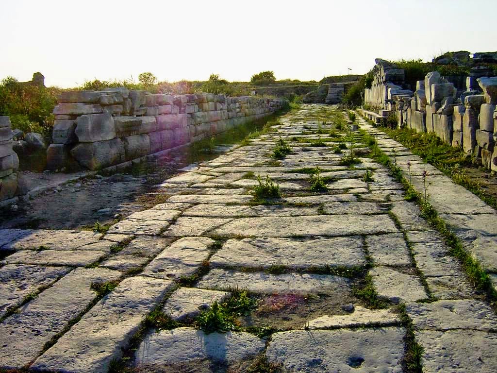
The slabs of the marble Agora floor are still in place, as well as the staircase leading to the square below, which connected to the Colonnaded Street that linked up with the Via Sebasté down in the valley. What a panorama from here! It is at least as impressive as my first meeting with Delphi in Greece – one of those places that only the gods can choose.

Behind this Agora, half of the Odeon has been exposed. It doesn't look as if it survived the centuries too well, for it has been stripped of its marble coat, and all I see is the rough brick support. The shape and the method of construction are clearly visible, however.

Via a narrow street and a left turn, I reach the Bouleuterion, a square meeting room counting 250 seats. Three bronze statues representing the people, the city, and the senate at the entrance must have welcomed the attendees.

Next to it lies the Heroon from the early days of the first century AD, delicately restored with its magnificent friezes of dancing and music-playing girls. Although these friezes are mere copies (the originals were also moved to the Museum of Burdur), they give an excellent idea of how they once looked. The hero in whose honor this Heroon was erected remains unknown, although some pretend it might be Alexander the Great. This may be wishful thinking, for although the hero's head now on display at the Burdur Museum closely resembles Alexander, I am a little skeptical.

At the foot of this Heroon lies the Upper Agora, dating from the Hellenistic period and enlarged in the first century. The great attraction is the ostentatious fountain, the Antonine Nymphaeum from 160-180 AD that looks like a theater front with six niches that held statues from the late fourth or early fifth century AD representing Asklepios, Koronis, Nemesis, Apollo, possibly Hygeia, and an unidentified male. Each corner hosted a beautiful larger-than-life Dionysus with Satyr, now also in Burdur (with the other statues). In-depth research has revealed that the fountain was repaired in the fourth century and that the statues came from the Temple of Apollo Klarios in the lower part of the city. Each corner of the Upper Agora is enhanced with a 13 meters high honorific column for the city's most prominent families, whose children later would become the first Roman citizens of Sagalassos. After the earthquake of 650 AD, the entire Nymphaeum collapsed and was never restored. I hear that today the monumental fountain has been so meticulously repaired that the water is again pouring into the broad water basin. That is a "must-see" for my next visit.


Public buildings surround the Upper Agora, where I find Greek and Latin inscriptions. In the middle of the Agora are the remains of a kiosk, initially a small temple dedicated to Tyche with a pyramidal roof and built in the days of Emperor Augustus. It was later reused by Empress Constantia (4th century AD), followed by Emperors Gratianus and Valentianus, and again by Empress Flavia Eudoxia (5th century AD).

Below and southeast of this Agora lies the food market or Macellum from the end of the 2nd century AD. It is a mere square of 21x21 meters with, in its center, a Tholos with a small fountain or water basin to keep the fish fresh. Shops surrounded the Macellum only on three sides, the fourth side being delimited by a colonnade offering a magnificent view over the lower city. Things were spoiled around the beginning of the sixth century when the shops were entirely rebuilt with rubble and lots of spolia from other monuments.

What a pleasure to walk around, especially since I am about the only visitor – so gratifying!

After a look at the necropolis, which is largely fenced off, I turn to the eastern side of Sagalassos. Here lies the exciting and now roofed Library of Flavius Soverianus Neon from 120 AD with its well-preserved mosaic floor. It was inspired by the Library of Celsus in Ephesos, although I personally fail to see how. For a start, this construction is much smaller, measuring only 11,80 x 9.90 meters, and the impressive façade of Ephesos is entirely absent here.

Right beneath the Library is another fountain, a Nymphaeum with Doric columns supporting the preserved roof above the water basin – a rare example of Hellenistic art from the first century BC. This Nymphaeum was the first to be excavated, and to everybody's surprise, as soon as it was exposed, the water started flowing again! Isn't that amazing? The flow is less than it used to be in antiquity simply because the water comes from one source, whereas there were several in antiquity. The fountain's edge is deeply eroded by the many jars pulled out of the freshwater, and the presence of those women drawing water is almost palpable.

The inevitable Roman Theater completed between 180-210 AD, is cozily nestled in a curve higher up the hill. However, it was built in Hellenistic tradition on a Greek foundation with seating in three-quarters of a circle. No excavations have been carried out yet, and the stage seems ready to collapse any day for the past two thousand years. The fault line of the devastating earthquake of 661 AD actually ran right in front of the podium, clearly separating it from the 9,000 seats. Strangely enough, the stage of this theater was only one story high. The reason seems to be that the Sagalassians wanted to see the flat-topped conical hill in the background, where Alexander defeated them in 333 BC – a later honor to the great conqueror!

On the high plateau behind it, the city's unique potters' quarters have left thousands and thousands of shards, ranging from plain earthenware to exquisitely decorated pieces. This place is so unique because of the five known potters' centers spread around the Mediterranean Sea. Only two have been localized: this one and another one in Pergamon, which is entirely flooded after the construction of a barrage. Unforgivable to flood antiquities like that, but it seems to be Turkey's policy, as we have seen at Zeugma and Allianoi

At the heart of the exhibition in Tongeren, Belgium, a scale model of Sagalassos was presented. It is incredible to discover how many temples, baths, nymphaeums, and private houses have been mapped out over the past decennia.

The latest excavations focused on several Roman villas, which I have yet to see but look very promising. There is this vast mansion just beyond the Roman Baths, which, when it was completed in the fourth century, counted no less than 66 rooms spread over several terraces on the slope. The oldest part dates from the first century BC and over the years, the villa has been extended and restored many times. By the 6th century, it was split into at least four smaller apartments in which the luxurious quarters were transformed into storage rooms and even stables! So far, we know that the construction collapsed during the heavy earthquakes of the 7th century and was no longer occupied. There are many more mansions like this one in the area, i.e., east of the Colonnaded Street, but also on the opposite side, which is much more terraced. Yes, high time to pay Sagalassos another visit.

The cherry on the cake is a visit to the nearby Museum of Burdur to treat yourself to the original dancing girls from the Heroon and the grand statues of extreme beauty from the Upper and Lower Agora fountains.

Tuesday, February 24, 2015

Full color on the lion horoscope of Nemrud Dag - updated

In an earlier blog “The Lion Horoscope of Mount Nemrud”, I spoke in detail about this intriguing horoscope on top of the lion relief that has been deciphered recently.

In the frame of the present exhibition about Mount Nemrud at the Allard Pierson Museum in Amsterdam, a special colored version of this relief has been developed and the result is quite amazing: the lion actually smiles! What is more, thanks to recent research the exact date of this horoscope has been established as being 14 July 109 BC (17h17 Universal Time).


Although the lion at Allard Pierson is only a copy, I think it is worth the visit as a full color picture is hard to imagine when facing it at the top of Mount Nemrud.

As always, the exhibition is well documented with clear maps and drawings showing the statues with their heads back in place. It seems the International Nemrud Foundation is working very hard to protect the ensemble against snow and wind, and they even seem to be in the process of hoisting the heads back on top of the sitting torsos - although the archaeologist are very well aware that the next earthquake may shake them from their support once again.


Sunday, February 22, 2015

Visiting the ancient city of Babylon

For once I want to share the entire article I found about an aficionado visitor to the remains of Babylon. So few people can really go there and walk the Processional Way used by Alexander the Great when he entered the city in 331 BC that I only can relay this wonderful description.

Although the author, Osama S. M. Amin, was enchanted by the spirits of Nebuchadnezzar I still envy him for I am certain I would feel the spirit of Alexander walking through those abandoned streets. After all, this is also the place where the great conqueror died in 323 BC. 


We had a 4-day national holiday. Meaning what? No clinic and no hospital! I said to myself, “It’s been a long time since I have visited Babylonia.” I drove my car for about 11 hours, continuously. Finally, I was there. I went to my uncle’s house, which lies about a quarter of hour from the ancient city of Babylon. The ancient city lies within modern-day city of Hillah, the center of Babel Governorate, Iraq, about 83 kilometers south of Baghdad, the Iraqi capital city.

After the US-led invasion in 2003, the American and Polish armies established a military base within the ancient city. God only knows what happened there during their presence! A British Museum report has found that extensive damage was done to the site by this military occupation. In 2009, the local government of Babylon opened the city to the public.

It was a very sunny and hot day in mid-July, with temperatures exceeding 55 oC (131 F). I took 8 bottles of cold water with me!

A general view of the ancient city of Babylon. The picture was shot from Saddam’s Palace, which lies on a mound which looks over the city. The South Palace of Nebuchadnezzar lies on the right. Babylon, modern day Babel Governorate, Iraq.

After passing through the checkpoint and doing the security check, I found myself in front of a replica of the Ishtar Gate; this marks the entry into the old city of Babylon. No one was there; the employees were sleeping. I and my cousin went through a large courtyard, where the “Nebuchadnezzar Museum” lies; this museum was looted by local criminals during the US-led invasion of Iraq in 2003 and has been closed ever since.

Then, I faced the processional street. The street is long and is divided into three parts. The first and the third parts are surrounded by fences to prevent people from entering. The original tiles are still in situ! Former president Saddam Hussein ordered the reconstruction and renovation of the ancient city of Babylon during 1980s CE and some of the walls, foundations, and buildings were buried and were replaced by modern ones.

At the right side of the Processional Street lies the Ninmah temple. In went inside it and found that some walls and roofs of the temple were in a very bad condition and no recent renovations have been done.

After that, I went once again to the Processional Street. An archaeological team was digging into some part of the foundations of the 2nd part of the street; they uncovered the relief of a Sirrush (a four-legged Babylonian mythological creature)! At the end of the Street, turn left; the Lion of Babylon statue appears! “It has been there, standing on that man, day and night, under the sun and rain, for 2600 years,” I said to myself in awe. The pedestal and the surrounding area were undergoing a renovation work. The statue itself was left, as it is, untouched.

Ruins of the North Palace of King Nebuchadnezzar. This palace was not reconstructed during Saddam’s era. Neo-Babylonian period, 605-562 BCE. Babylon, modern day Bebel Governorate, Iraq.

The ruins of the North Palace of Nebuchadnezzar II were next. These ruins were not touched during the 1980s’ work. The inner walls of the city of Babylon are located just behind this palace, and they look like they are about to collapse. The walls looks over the South Palace of Nebuchadnezzar II; this palace was rebuilt completely during Saddam’s era and its older walls, rooms, and foundations were completely buried underneath this modern palace.

Although the city and its content underwent a very comprehensive renovation, using modern bricks, the scent of history and the power of king Nebuchadnezzar II are still there; I can feel it! My cousin got bored and our companion was hungry and drowsy; I shot more than 900 pictures and wanted more, but what to do!

I really enjoyed seeing the stamped bricks, and smelled the ancient walls. “Nebuchadnezzar II lived here and this person had changed the path of the history,” I told myself. Saddam Hussein tried to revive Babylon and he portrayed himself as the new Nebuchadnezzar; a policy which intended to create a propaganda in order to frighten a nearby country in a very hostile way. He, instead, re-shaped the city and destroyed what Nebuchadnezzar II had done!

Wednesday, February 18, 2015

Along the Via Egnatia: Apollonia in Illyria

The Via Egnatia, as mentioned earlier (see: Via Egnatia, a road to remember), was built by the Romans in the 2nd century AD and served as a major connection between Byzantium and Rome. As far as the Illyrian part is concerned, the road came from Ohrid (Republic of Macedonia), then ran through Elbasan, where it split in two, one arm connecting directly to Dyrrhachion (Dürres) and another one crossing Apollonia and Antipatrea (Berat) to end also in Dyrrhachion on the Adriatic coast where ships ferried people and goods to Brundisium (Brindisi) on the Italian side. 

To name a city after the sun god Apollo seems to have been very popular in Greek history as we find several cities by the name of Apollonia in Turkey (Lycia, Mysia, Pisidia, etc.); in Sicily, Italy; in Greece itself (Thessaloniki, Chalcidice, Kavalla, etc.) and in Crete; in Libya, where it was the harbor of wealthy Cyrene; and finally here in Illyria, modern Albania.

This time, I’ll be concentrating on Apollonia in Albania, located about 7 kilometers from Fier (see: Alexander’s psychological warfare in Pelium, Illyria). The city is well documented during Roman times, and the remains are obviously very Roman too. For Alexander, this was deep into the Illyrian country, just beyond the northern border of Epirus.

The original name was Gylakeia, after its founder Gylax who belonged to the Illyrian tribe of the Taulantii. It was the Greek colonists migrating from Corinth and Corfu in 588 BC who changed the name to Apollonia. They were the ones who controlled the city and ruled over the Illyrians. Money was made from the slave trade and agriculture, but maybe mostly through the supply of asphalt, which was a valuable material for the caulking of ships in antiquity. Located on a branch of the Via Egnatia, it is obvious that it was an important harbor along the Illyrian coastline to link up with Brindisi on the other side of the Adriatic Sea and a transit port for all kinds of goods traveling between Byzantium and Rome.

This is the area where King Pyrrhus (a great-nephew of Olympias and cousin of Alexander the Great) ruled roughly from 306 to 272 BC while mingling in Macedonian affairs in the wake of the Diadochi Wars. He tried to keep the Romans out of Illyria, but by 229 BC, they firmly established themselves. I find it rather strange that Apollonia, like so many other Illyrian cities, was so loyal to the Romans. Maybe that is because the city was rewarded with the booty taken from their defeated King Gentius of Illyria – not very patriotic, I would say. By 148 BC, Apollonia became part of the Roman province of Macedonia, Epirus Nova. About a century later, the city supported Julius Caesar in his war against Pompey but fell into the hands of Brutus in 48 BC. Apollonia could also boost to have contributed to the education of Emperor Augustus, who studied at its famous school of philosophy in 44 BC, where Athenodorus of Tarsus was his teacher. Together with other cities in the area, Apollonia flourished and was even mentioned by Cicero as “magna urbs et gravis”, meaning “a great and important city”. Strabo also mentions the city in his Geographica as “an exceedingly well-governed city”. Decline set in during the third century AD when its harbor started silting up after being hit by a severe earthquake which changed the course of the Aoos River. The inland turned into an ever-growing malaria-ridden swamp, and the inhabitants moved out to resettle at nearby Avlona (modern Vlore).  Only a small Christian community that moved in during the very early days of Christianity remained; they may have built the first church of Saint Mary. Today’s church dates from the 14th century and houses the local museum.

The visitor’s attention is immediately drawn toward a colonnaded façade that could be part of a temple. Still, it turns out to be the entrance to the Bouleuterion from the second century AD – quite unusual since generally, the tiers of such a city council survive but not the portal. The columns are definitely Corinthian, and in the architrave above them, we can still read the Greek dedication: “To the memory and in honor of Valentinus Villius Furius Proculus from his brother Quintus Villius Crispinus Furius Proculus, prefect of a cohort in Syria, tribune of the Legion Gemina in Pannonia, and president of the sacred games. A fight of 25 gladiators was held for the inauguration.” This Bouleuterion is surrounded on three sides by rooms, some kind of annexes to the Ionic Temple next to it. What is left are mainly low walls, and archaeologists suppose that these rooms were used for administration or for the priests’ duties. The outlines of the temple itself are easily located with a few columns sticking out from the grass.

Across from the Bouleuterion are two big stumps of stone indicating the site of a triumphal arch at the end of the street leading into Apollonia and dating from the 3rd century AD. To the right, but difficult to make out, are the remains of a Library from the 2nd-3rd century AD, proof of the city’s importance – if needed. On the other side of the street lies an Odeon that has been carefully restored and could hold as many as 650 spectators. Adjacent is a small Sacellum, an open sanctuary dedicated to an imperial cult. The niche was most probably flanked by two Ionic columns, and we still can see the rosettes and lion paws of their base.

It is followed by a portico, 78 meters long, punctuated by 17 niches that once held marble statues. This portico seems to date from the 4th century BC and was divided lengthwise in two by a row of Doric columns, whereas the outside columns were of Ionic style. I am told that this kind of structure is unique for Apollonia.

The portico ends at the Sacred Road, where we find a temple right around the corner, dating from the second half of the 2nd century BC but probably renovated four centuries later and possibly dedicated to Jupiter, Juno, and Minerva. The Sacred Road continues further uphill to the Acropolis, where little or no excavations have been done. With a width of nine meters, it is the widest street so far in Apollonia, paved with river pebbles laid directly on the clay surface.

On the other side of this Sacred Road are three vaulted shops, almost square in shape (3.45x3.40m), whose entrance could be closed by heavy double doors. The walls were very thick to keep out the moisture and guarantee a nearly constant temperature in order to preserve the goods stocked inside. They seem to be built during the second half of the second century AD. Against these shops, another construction deserves our attention, for this is a water cistern that was used from the 4th century BC all the way to the 2nd century BC and still has kept its impermeable inside coating.

Opposite this Sacred Road are the remains of a large villa, in fact, no more than a succession of mosaic floors. The house was divided into four parts: an entrance portico of 14x5.8 m right opposite the Sacred Road; the main room measuring 12x11.8m with a center of white mosaics surrounded on all four sides by a corridor 2.9 m wide paved with little brick squares of 5x5 cm; the back room overlooking the sea. It is thought that this house was used as a gathering place for the believers before starting their procession over the Sacred Road. The most precious mosaics have been covered, of course, but the remaining ones are quite interesting. The attentive visitor will also notice the clearly Roman sewage system running parallel to this building.

Like every single Greek city, the location of Apollonia was chosen with the greatest care, overlooking the Aoos River and its fertile valley with the Adriatic Sea at the far horizon.

My greatest surprise, however, was the local museum, housed in the 14th-century monastery attached to the church of St Mary, by itself worth a visit. Under the watchful eyes of the soaring Pantocrator, it is easy to discover all sorts of antique fragments: Corinthian capitals placed upside-down to serve as a base for some Christian relic or flowers; the marble wall of a well with deep gutters left by the ropes that pulled the water-buckets over the centuries and now on dry land; small lidless sarcophagi turned into mini-gardens; and other spolia spotted in the outside walls. In the upstairs portico leading to the very entrance of the museum, several grave steles and smaller altars have found refuge.

Since I have been walking through Roman Apollonia, I expect this museum to reflect that image. Well, not entirely so, for originally, the city was founded by Greeks who imported the art from their hometowns or created their own imitation. I walk among Attic vases and hydras from the 5th century BC, Apollonian bottles and pots, but also some Italic imports. The Hellenistic period is also very present with several marble steles, reliefs, busts, and statues, but the eye-catcher is this wonderful shield that I immediately recognize as Macedonian. But wait a moment … according to the label it seems to be Illyrian! How on earth is that possible? I take a closer look at this splendid piece with three concentric circles in its center around the frightening head of a Gorgon in Classical Greek style sticking out its tongue and staring at me with shiny inlaid eyes. The border of the shield also counts three concentric rows of circles framing six half circles around the edge. I fail to see what makes it Illyrian and inquire with the museum director, who tells me that the difference lies in the curving. Well, I suppose he knows, but I am not entirely convinced till I see other examples of Illyrian shields later on in Tirana and at the Skanderberg Museum. I’m totally baffled by this revelation! Ironically the Illyrian shield in Apollonia is presented next to a splendid Macedonian helmet that has been dated to 314-312 BC, a rather narrow timeline.

So, all in all, Apollonia was definitely worth a visit, including the local museum. Some artifacts, however, have been moved to the national museum at Tirana where I discover a hoard of silver drachmae from the 1st century BC, as well as a head of Demosthenes (1st century AD) – of all people, what is he doing here?

I’m not too far away from Alexander, after all!

Monday, February 16, 2015

Traces of Alexander’s siege at Gaza?

It would be too good to be true, of course, but rumors have it that a military outpost recently excavated near Gaza may have been destroyed by Alexander the Great.

The news as announced in the Jewish Press is rather confusing as they talk about a Persian military site including a fortified town and a military tower dating from about 100-0 BC – far too late to tie it to Alexander. The tower with a partially surviving staircase, was built of limestone and mud bricks. Inside the warehouses, archaeologists discovered intact pottery and utensils, as well as jars for the storage of wine and oil.

The fact is that the military outpost was abandoned in a hurry and its occupants left everything behind. The place definitely was burnt down as archaeologists found a layer of ashes.

Besides its military function, it is believed that the fort housed people who worked on the road connecting Ashkelon to Gaza.

Saturday, February 14, 2015

Amphipolis/Kasta Hill: five remains found inside the tomb

That’s about the latest fact that has transpired: five people have been buried at the Amphipolis/Kasta Hill tomb. According to the latest announcement made by the Greek Ministry of Culture, there were four burials here and one cremated body.

[Picture released by Greece ‘s Ministry of Culture]

It has been determined that the remains are those of a woman approximately 60 years old (not exactly what was mentioned before), two men of 30-45 years and a newborn baby; the cremated remains are those of an adult who was incinerated prior to the death of the other four occupants of the tomb. DNA tests will have to establish whether there is any family relation, although that will be more difficult with the cremated person for whom the tomb was initially built.

Once again speculations are flaring up, hoping to attribute the bones of the woman to Queen Olympias and to identify the two male skeletons as sons of Cassander, one of which was murdered. For the cremated body or the infant no suggestions have been put forward. However the skeleton of the woman shows no sign of stoning which caused Olympias’ death. The youngest of the males probably was murdered with a knife.

These are the latest facts. I do not want to venture into further speculations, enough has been said already, I think

Thursday, February 12, 2015

Miletus, Alexander’s first siege in Asia

While Alexander was still in Ephesos, the Persian governor of Miletus, Hegisistratus, made his appearance at the court. He came in peace, offering the surrender of the city. At that time, Miletus was the largest Greek city on the eastern shore of the Aegean Sea.

Its origins go back to Mycenaean times in the 11th century BC. In 670 BC, Miletus started colonizing the coast of the Black Sea, the Mediterranean, and the Sea of Marmara. Just like Priene and the other cities belonging to the Ionic League, Miletus suffered from repeated Persian invasions and occupations, the most memorable of which happened when Cyrus defeated Croesus of Lydia, causing the fall of Miletus. In 499 BC, however, this city led the Ionian Revolt against the Persians, punishing Miletus and destroying the mighty city, but it soon recovered.

So, by the time Alexander arrived in 334 BC, Miletus was in Persia's hands only because its excellent harbor was their main base, ideally situated to control the other cities of Asia Minor or launch a counter-attack on mainland Greece. Miletus was surrounded on three sides by the sea and had strong fortifications on the landward side. It is not surprising that Alexander welcomed Hegisistratus’ offer.

In this context, Alexander marched towards Miletus with only a small number of troops in his entourage. Yet, at the same time, news reached Hegisistratus that a 400 warships strong fleet of the Persians was only three days away. This gave the governor new hope and a good reason to resist the Macedonian king, who found the city gates closed upon arrival.

Meanwhile, Alexander’s own fleet of 160 ships commanded by Nicanor (brother of Parmenion) had anchored on the island of Lade, just off Miletus. The island was fortified with 4,000 men strong garrison ready to make it difficult for the Persians to use the harbor for their operations. Consequently, the Persian fleet was forced to land off Mycale, some 15 km south of Miletus. The situation at sea seemed locked for the time being. Alexander decided to begin besieging Miletus from the land side, confident that the Persians were in no position to help or reinforce the city from the sea.

For the time being, Alexander made himself comfortable in nearby Priene and directed the siege operations from there. Here, he was approached by an unexpected embassy led by Glaucippus, a well-respected citizen of Miletus. His proposal was that Miletus would become a free city, meaning that both Persians and Macedonians could use its harbor at will. If he had accepted, Alexander would allow the vital port of Miletus open to the Persians, who had access to the entire coast of Asia Minor.

Early next morning, Alexander moved his siege engines forward, probably including his stone-throwing catapults. Artillery was used to chase the defenders from the walls, after which the battering rams and scaling ladders were brought in. The wall crumbled soon enough, and the city was quickly taken. The Greek fleet, which had positioned itself as a ring around the city, successfully prevented the Persians from giving Miletus any assistance.

Panic broke out among the citizens of Miletus, who immediately offered to surrender to Alexander. Alexander probably accepted their plea, but he slaughtered nearly all the Greek mercenaries who had defended the city from the Persians. Only about 300 of these mercenaries escaped, using their shields as makeshift rafts to peddle to safety on one of the many rocky islets off Miletus. Of course, Alexander was not going to leave it at that and mounted scaling ladders to the front of his triremes to be used by his men to land on the islet. On the other hand, the mercenaries did not ask for mercy but were prepared to fight to the death. At this point, Alexander showed clemency, and in the end, they were included in his army.

With Miletus taken, Alexander could now concentrate on eliminating the threat of the Persian fleet. He did not want to get involved in a naval battle because his fleet was much smaller, and the men on board were not trained in maritime warfare. Instead, he sent Philotas by land to Mycale, preventing the Persians from landing and getting new provisions and fresh water from the River Maeander. The fleet withdrew, seeking protection on the island of Samos instead. Eventually, the Persian fleet moved south to the safety of Halicarnassus, which was still in Persian hands.

This being settled, Alexander elected a democratic leader, canceled all taxes, and boosted commerce – in short, he started a new period of prosperity for Miletus. This prosperity ended with the arrival of the Romans in 133 BC, who imposed high taxes now that the city was part of their Provincia Asia. By the third century AD, Miletus’ decline set in as its harbors silted up and marshes were formed.

Today the antique city is to be found 10 km inland, and in springtime, the once so busy port is covered by extensive marshlands filled with reed and blooming irises. In a way, this helps to imagine what this vast harbor must have looked like. The old rotunda was part of the Harbor Monument built in honor of Pompey in 31 BC, still surrounded by water. This Monument must have been at least 7.5 meters high and may have carried a big iron pot on top, part of which is now on display at the Pergamon Museum in Berlin. Maybe, after all, it was a beacon? Although the marshes are omnipresent in springtime, the land is dry in autumn, meaning that the visitor gets quite a different view of Miletus in either season.

In historical literature, Miletus is described as less impressive than Priene, but I think that is somewhat cliché, for it is just different.

The most striking building is the theater sitting on the hilltop, commanding the entire city of Miletus. It is one of the most splendid constructions one can imagine, not only because of the many tiers of seats that have been so well preserved but also because of the entrance gates and the near-intact vaulted corridors. This theater clearly illustrates the high level of architecture reached by the Romans; the very concept of theater is highly efficient. Easy walking steps take the visitor to the cool entrails with fascinating views over the surrounding landscape and the interior of the theater itself. The first theater was evidently Greek, built in the 4th century BC, and counted approximately 5,300 seats; the Romans extended it in the 2nd century AD to hold 25,000 people. The façade is impressive enough, 140 meters long and 30 meters high. It is hard to imagine this theater's full impact since the upper tiers' stones have been taken to build the Byzantine church on top, leaving a merely seating space for 15,000 people.

From up here, one can easily see the layout of the entire city. Following the marshy water line from the harbor, I find the Delphinium, the open-air Temple of Apollo Delphinius, the protector of the seafarers and the ships. The four remaining columns of the Ionic Stoa next to it quietly reflect their image in the still waters covering the North Agora. Sitting in the shadow of these columns, I discover an ancient graffiti of a fish and the Greek word IΧΘΥΣ, both symbols that were used by early Christians – what a rewarding moment!

The remains of the adjacent Hellenistic Gymnasium are relatively poor, and the colossal Nymphaeum from the 2nd century AD flanking it on the other side requires lots of imagination to picture it. Across from the Nymphaeum are the remains of the Bouleuterion, built between 175 and 164 BC. But here, as elsewhere, the parts belonging to the Hellenistic period blend in very harmoniously with those added later by the Romans.

Further south, past the South Agora, the Baths of Faustina, Marcus Aurelius wife, are visible; rough brick arches and walls don’t do justice to the once so great building whose ornamental statues are now in the Archaeological Museum of Istanbul. These baths date from 43 AD, and I’m not surprised to hear that they served as a role model for the Turkish baths, the hammam. This South Agora belonging to the 2nd century AD measures an impressive 196x164 meters and must have been dwarfing. The southern entrance gate to this Agora has been entirely moved and reconstructed at the Pergamon Museum in Berlin (unfortunately, it was under restoration when I visited the museum).

It certainly is worthwhile to visit Miletus in spring and again in fall when the water level has receded, and the Agoras show their large slabs of marble flooring. At that time, the outline of the different buildings was much more recognizable, which truly helped to get a comprehensive view of the city.


Between the Baths of Faustina and the South Agora lies the Temple of Serapis from the 3rd century AD. Not much is left except the re-erected pediment showing a relief of the god Helios Serapis wearing a crown of sun rays. The rectangular buildings seen on the right-hand side are warehouses.

That brings me to the most exciting location in Miletus, the Sacred Road that led all the way to Didyma, the city renowned for its oracle. The first road must go back to the 6th century BC at least, but it has been improved and embellished over the centuries. In 100 and 101 AD, Emperor Trajan, for instance, raised the road level and made the necessary repairs. From the early days onward, this Sacred Road was lined with statues of the Branchidae (priests and priestesses attached to the temple of Didyma); crouching lions and sphinxes; votive fountains; and even monumental tombs and sarcophagi belonging to important persons. None of these features are to be seen anymore since all were moved to the British Museum in London, the Archaeological Museum in Istanbul, or the local Museum of Miletus. This 16.5-kilometer-long road was entirely paved and had a width varying between 5 and 7 meters. Both in Miletus and in Didyma, it is still pretty easy to locate a sizable stretch of this Sacred Road; just have a close look. I was so lucky to be put on the right track by Peter Sommer during my travel on his tour "In the Footsteps of Alexander the Great" - a most rewarding experience! 

I have not found any indication about the road used by Alexander on his way from Miletus to Didyma, but I like to believe that it is rather evident that he would have followed this Sacred Road. For me, this is another place where Alexander’s presence is still tangible. 

[Click here for more pictures of Miletus]